
Londoners have always liked maps, perhaps because they use them every day to find their way around this massive city. The most famous map is also a work of art – Harry Beck’s 1931 design for the underground – and almost every household has a battered old A-Z somewhere.
But over the last year there has been an explosion in mapping over the internet and the craze shows no sign of abating. Maps have become entertainment as well as tour guides.
Whereas previously your friends may have used Facebook and Twitter to link to cat videos on Youtube or crazy pictures on Flickr, now they’re also linking to maps that help us to see London in a new light.
What does the BBC use to mark the death of musician Gerry Rafferty? Not just an obituary, but a map of hit songs about locations in London including Rafferty’s own ‘Baker Street’.
Maps have long been used to illustrate more than just geography – take a look at John Snow’s 1854 cholera map, the Temperance Society’s 1886 map of public houses, or even Wenceslaus Hollar’s map of the damage caused by the Great Fire of London in 1666.
But these days maps are easier to create than ever before, even for non-geeks. Want a map to help you avoid the police during the student protests? Or a map of ‘non-Boris‘ bike racks in central London? You got it.
New mapping sites are popping up nearly every day, some of them genuinely impressive even if their actual use is limited. As you’d expect, transport is a common subject. This real-time map of London tube trains was doing the rounds throughout December, as was the London ‘Boris’ bike share map and this neat map/display showing the travel time between every tube station. And if you prefer buses, there’s an animated ‘flowprint’ of London bus journeys.
What else can you map? Well, there’s communities like London’s football supporters, there are maps showing how badly London was hit by German bombs during WWII, but how about animating the first night of the Blitz?
Books and film? Find the local libraries threatened with closure, pore over an interactive map of more than 400 books set in different areas of London or 100 locations used in films.
Then art, and this staggeringly massive hand drawn map of Greater London and a map of Banksy graffiti locations. But there should also be a London version of these strange ‘graphical anagrams’. Naturally companies are jumping on the map craze to sell artworks – would you like a London typeface map? That’ll be £43. Or how about £99 for a canvas map to put on your wall?
People are also swapping digital copies of startling historical artifacts, such as these plans for railway stations in London 1864, an old tube map from 1908 or even a mystifying map of ‘social and functional analysis’.
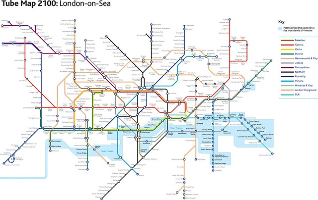
And what about the future? A map works for that too – such as this vision of London-on-Sea in 2100.
Is this just a passing craze? Projects to keep an eye on include this one to add 3D models to London on Google Earth or the strangely relaxing London Sound Survey, which offers the chance to listen to recordings with titles like ‘Under Tower Bridge’ and inside ‘St Bartholomew the Great’ church (mostly quiet, with occasional bleeps from a tourist’s camera). Then there’s always the London 2012 Olympics.
And if you need a weekly fix of all things cartographical, then check out the blogs Google Maps Mania or Map of the Week for a regular fix.